
By summer 2011 I had now done five stints in West Greenland – I had spent four Julys and one May out there. Strangely, and unexpectedly, this remote region in the Arctic had now become a place so familiar to me that it was like being at home in Snowdonia. Over the last three of those visits, (2008, 2009 and 2010), I had spent all of my time in an area of about 160 square miles (414 square kilometres) in which I can now vividly visualise my way around practically all of it. I find that a bit astounding from my personal perspective considering the remoteness and wildness of that particular part of the globe and for that same reason, there’s something deeply satisfying about knowing such a place so well! Through that time-earned familiarity I now feel a strong bond with this landscape and visiting time and again is like coming back to see a dear old friend and delighting in the company for a few weeks. It’s tremendously satisfying to be able to wander such a remote place and simply know my way around amongst its ridges and valleys and lakes.
When plans were being discussed to have a small group out there again in 2012 to do some more wild goose work in that area, I had a mind to take the opportunity to explore a little more of this vast countryside before I joined that small team. I had a mind to immerse myself more deeply in that landscape which I very much prefer to do alone and I wanted to have some personal hiking time before I joined up with the others.
So I pulled out the maps and laid end to end the three sheets required to see the whole of the area between the ice sheet and the west coast…a total distance of about 120 miles (193km) in this region. The official Arctic Circle Trail (ACT) is clearly shown on the maps but having walked that in 2007 I wanted to make my own way east from the coast and not follow in the footsteps of others. At 1:100,000 scale, the level of detail the maps give you is a long way from the customary 1:25,000 OS maps in the UK but by reference to the areas I knew intimately, planning and estimating time and distances for a new route felt very easy and satisfying. Despite the relative paucity of topographic detail and resolution, I found myself visualising the likely look and feel of terrain I had not seen before with an odd sense of familiarity and much confidence.
Route options abound plentifully when you’re looking at a huge area of pure uninhabited wilderness and I looked at various possibilities carefully pondering what each valley, ridge and lake-basin had to offer. The only limitations on choosing your route are your own confidence in the undertaking, your comfort threshold with being alone so remotely, and how much you’re prepared to carry. (I am comfortable with carrying about 36 Kgs for a 100 miles through this terrain. My 2012 pack was significantly heavy but in 2014, with this route then known to me it was about 36Kgs, and about the same in 2017…keep in mind that I’m not speeding along the easy facility of the ACT, I’m going another way and I’m out there for two or three more weeks after I complete my hike).
Each route option was considered in terms of time, distance, the weight I’d be carrying and likely date of arriving at the target destination to join with the rest of the team and make a respectable contribution to that fieldwork. Even now however, I knew there would be new choices that would present themselves once I was in the terrain. There is a lot of relief that doesn’t resolve itself on a map at 1:100,000 scale! Still, for the time being I eventually settled on a proposed route. Starting at Sisimiut on the coast it should be a little over 100 miles to reach the others at the appointed location in the east.
Here I might digress slightly from 2012’s hike for a moment as it occurs to me that those who’ve been interested in my Greenland travels and urged me to write something might like me to expand a little on my motivations before we get into the walking. This is what I like to call “big country”. There is a very dramatic sense of huge, expansive uninhabited wilderness around you. Apart from the two towns (a hundred miles apart) in opposite directions somewhere over your horizon, one on the coast and one inland, it’s a very long way in any other direction to any human habitation. Within that landscape, there are countless lakes and so many valleys and ridges amongst which you can disappear and given where I planned to go, I expected not to meet anyone else. Indeed I was dearly hoping not to! I would very truly have been deeply disappointed just to see another wanderer out there far from the only official trail let alone meet someone. To see another human out there, even in the distance, disappearing over some ridge-top, would have irretrievably broken the spell I was looking to invoke for myself. I very much wanted to extend my experience of solitude, to intensify the sense of isolation in that wilderness to another level, and delight in a blissful period of being off-grid and away from all of humanity’s ugliness. Happily I achieved what I wanted and it was so good that I wanted more…doing it again in subsequent years.
A little over 100 miles to walk in that landscape, and away from the official route, is not an insignificant undertaking, especially since I prefer to hike alone out there, so I need to ensure that I will be happy to commit. One of the things that I do to underpin that is study maps intensely. I visualise the overall route generally but I will also trace my way very slowly across those contours, up that valley, around that lake…visualising the terrain as I go, estimating time and paying close attention to every place – when I reach this point I should be able to see x; this will be a bit of a climb; this might be a good place to make camp for the night; here I will turn south and so on.
I don’t want to be walking with my head down staring at a GPS unit with a pre-programmed route in it and I don’t want to be constantly taking a compass bearing and trying to walk point to point. I want to feel that I am getting to know the landscape, that I’m forging a very personal link between me and the terrain and that starts with properly studying the map. Of course, there may be a time and place for hugging a line on a GPS unit closely but I use my GPS unit out there for daily stats and have it as a precaution to derive precise location coordinates should I ever get into trouble.
Recently, I read yet another hiker’s blog about walking the ACT and again it was largely about the metrics, x miles to the hut, carrying y Kgs of food, ticked off seeing a Muskox etc. I understand that perspective and certainly get why others who might venture out there would want that kind of information. That was me back in 2005 when there were no such blogs that I could find or access, no websites and no guide book that I knew of. All I had was the three maps. One of the best sources for first hand advice on the ACT these days is the Facebook page for it at: https://www.facebook.com/groups/arcticcircletrail/ By now however I am in a much more fortunate position. I don’t need that kind of information and instead of ticking off a trek, I have found something about being out there that spoke to me personally and deeply.
For those wanting a brief impression of hiking the ACT there are lots of those, often short and concise, hiker’s blogs out there which can also provide assistance for planning a visit. I don’t intend to add yet another to those “what you need to know about the ACT” accounts, not least because I did not follow the whole of the official trail in 2012. I will include an occasional metric where I think it might be of interest and I will also use some photos from 2006 to supplement the visuals as I don’t intend to write that year up separately. So, if it interests you, I invite you to come along with me from the comfort of your armchair on my 2012 hike. If it does not interest you, read no further…
So, I will now return to 2012’s hike and my chosen route…
Initially, there was little point in doing other than following the familiar ACT from Sisimiut but after a few days I would leave the ACT and from there, wander into terrain completely unknown to me to find my plotted route east. That was a tremendously exciting prospect. I would not be looking for an obvious and well preserved path someone else had made, I would not be looking for cairns or splashes of red paint on a rock…there would be none to my knowledge. Nobody else would have pre-ordained the route for me…instead, as new vistas unfolded before me, I would decide for myself precisely where I would walk and which way I would go every step of the way from that point. Whither I wander would be my choice for every footfall I make and that prospect felt like the ultimate freedom and genuine ‘wild-walking’ as I call it.
On 7th July 2012, I did my usual thing, I flew from the UK to Copenhagen aiming to arrive late in the evening. From the South West of the UK, this means flying with KLM to Amsterdam, changing flights at Amsterdam and then flying onward to Copenhagen. Having done this several times, by arriving late in the evening in Copenhagen I can simply hang around at the airport overnight with my gear and sometimes I get lucky with finding a semi-comfortable place to sleep on and off, and sometimes not! The shop that remains open 24hrs at the airport (which used to be called a 7-11!) is much appreciated for the variety of foods and drinks one can buy there overnight.
As the number and bustle of people begins to increase around sunrise, I like to check-in my big pack with Air Greenland early in the morning, shortly after check-in opens, and then I have only my small pack to carry around. In that will be my hardware/tech stuff: lithium batteries, GPS unit, camera kit, binoculars, telescope and satellite phone amongst other bits and pieces so that alone weighs several kilos but it’s gear I don’t want thrown around! The camera must be in this so that if it’s a good day for crossing Greenland I can try to get some more nice shots from the plane of the spectacular east coast and the ice sheet proper (if I have a window seat!).
Given my plans to follow a different route east from the coast, and not the one trodden by thousands of hikers – (the ACT sees a good amount of people traffic nowadays) – it seemed a valuable opportunity for the ecological study I help with to treat my hike as a transect through undisturbed terrain and to see how far west I might encounter wild geese. It would be interesting indeed if I found any of our marked geese way out west so this meant that I was carrying stuff most ACT trekkers don’t need to carry. In addition to my food and other stuff, I was also carrying a 2Kg Nikon telescope, my 1Kg Swarovski binoculars, a large 1.6Kg Canon DSLR and also a heavy, sturdy Giottos tripod. A lightweight tripod is useless out there for my purposes.
The ACT will take about 8 days to walk comfortably but because I was taking a new route and then planned to be out in the wilderness for several weeks, I also carried more food than ACT’ers and quite a pile of spare fully charged batteries to take lots of photographs along a route I did not envisage repeating at that time!
So on the morning of 8th July, I took off around 09:00 from Copenhagen and arrived in Kangerlussuaq after a little over 4 hours of flying in the familiar red Air Greenland Airbus A330 called Norsaq. Amusingly, one arrives in Kangerlussuaq shortly after the time of departure from Copenhagen because the time difference is 4 hours. On arrival, I had time for my first muskox burger of the year at the airport restaurant which I am very fond of (meaning both of those things!). It’s a nice welcoming feeling when you recognise the restaurant staff and some recognise you. Then not long after, I checked in for the short hop of about 30 minutes in a Dash-8 to Sisimiut…arriving in the early afternoon of that Sunday. Given the general size of communities, Sisimiut airport is quite charming. Its terminal is basically one room where people waiting to depart and people waiting to pick people up all mingle. There is often a strong and warm sense of community as everyone seems to know so many others. You walk the short distance to the terminal from the plane and wait for some doors to open and everybody’s baggage is off-loaded from a large basket on a fork-lift onto the floor area. You then just retrieve yours and off you go to town. If only all air travel felt so friendly and relaxed!
I had last been here in 2007 and found that Hotel Sisimiut now had a completely re-vamped reception area. I chose Hotel Sisimiut because it is near the eastern end of town and therefore close to the start of the trail. After checking-in and dropping my gear off in my hiker’s rate room…(happily, there was nobody I’d have to share with that night), I wandered down into town for a look around and to buy my stove fuel and maybe some chocolate, sweets, treats…?! It was so nice to be back in such a distant place, with that pleasing sense of familiarity. It was a warm and sunny day in Sisimiut with a very light breeze. The mosquitoes were out in force that afternoon, so much so that many of the locals were wearing mozzie nets! Still, for me, it was pure joy to be in this town again…to be there on the west coast of Greenland in a town I had never heard of until 2005!

I had a mind to visit the northernmost Chinese restaurant I had ever been to for a fine dinner that evening…but when I got down to the harbour that afternoon, I was very disappointed to find it was no longer there! That it was there at all had certainly been a surprise in 2006! I recall it had been a very nice restaurant with authentic ambience and all the usual paraphernalia…chopsticks on little rests on the tables, jade dragons, Chinese paintings and other typical colourful ornamentations. It had an impressively extensive menu including dishes using local fish and caribou. I remembered having something with cubed pieces of caribou that were deliciously spiced the last time I was here but sadly the restaurant was now gone. The lady at reception back at the hotel told me it had closed a few years ago. Pity.

I had bought my stove fuel but given my unfamiliar plans, gave in to a sense of abundant caution and bought a little extra so that I would have sufficient spare fuel for any weather-bound ‘zero days’…a term I learned from a Twitter friend’s Kungsleden blog! If I had more than I needed for the hike, we could use it up with the others once I reached their camp in the east…but it was a little extra weight!
Back at the hotel, I decided to take a nice hot shower. An everyday ordinary act at home but here at this time, I was quite conscious of this simple pleasure and that it would be my second to last hot wash for the best part of a month! In fact of course, you can hold the thought but you can’t actually appreciate the joy of a hot shower until you have been washing outdoors in cold water for weeks! My longest stint out there without a hot wash has been 28 consecutive days of living in my tent and I can tell you, the first hot shower on getting back to town was a most wonderful sensation!
When it comes to my pack, re-jigging a few things at the hotel becomes necessary because I will not want an additional day sack (my ‘cabin bag’) of hardware hanging off me once I start the trail. So I killed some of the late afternoon in my room re-organising things a bit and packing away the stove fuel and any other items I had bought, all into the one big pack. With the food, including spare for any tent-bound days in the unknown, and all the hardware, including the sturdy Giottos tripod…I was well aware that this was the heaviest pack I had ever proposed to carry…a long way! I calculate that this pack was in the vicinity of 40Kgs when fully laden in the morning. Thankfully I had also brought my trekking poles for I was never blessed with rugby-player legs! The last item to add in the morning would be my usual 2ltr water bottle…the final 2 Kgs!
Given the sad demise of the Chinese restaurant, dinner that evening then was at Hotel Sisimiut. In a separate dining area I noticed that some well-attended corporate event was happening but in quieter surroundings in my part, I had a tasty muskox steak with new potatoes, salad, some garnish and a delicious very dark gravy. The meat was a little too rare for my liking but at least I might know what to expect should I end up desperately lost, surviving by gnawing on a dead muskox killed with my own hands or ingenious device!
I turned in at 21:40. After two days of travelling from the UK with just snatches of sleep at the airport terminal in Copenhagen I was looking forward to a good night’s sleep in a real bed…the last for several weeks.
Bang, whoosh, crack, whoosh…crack, bang…! It was 00:53 when I was woken to the sound of…fireworks right outside the hotel?! The display continued for about another 10 minutes and peering out of the window, seeing smartly dressed people standing around, I realised they must be connected somehow to the corporate event I had noticed earlier. I have to say though that you don’t get a very spectacular show when your fireworks are going off in daylight! (By the way, you will find that I am fairly precise with times in my field note book!)
So, Monday the 9th of July (day 1) dawned and I awoke at 05:10 to find it was grey and damp outside. It reminded me of the day when my friend and I set out from this same hotel in 2006, that too was a grey, damp day but it was also gusting with strong winds. When we reached the water reservoir on the edge of town, water spray was being whipped from the surface waves and blown horizontally across the lake! Fortunately, the wind wasn’t gusting like that today.
Plodding downstairs to the restaurant in my Crocs, I enjoyed my last decent breakfast and then spent about an hour finally readying my pack, making sure my waterproofs and woolly hat were easily to hand, and also my towel for river crossings. As I prepared to step out of Hotel Sisimiut I was much aware that this was a seriously heavy pack and thought how much lighter it would have been were it not for carrying the birding optics and other hardware.

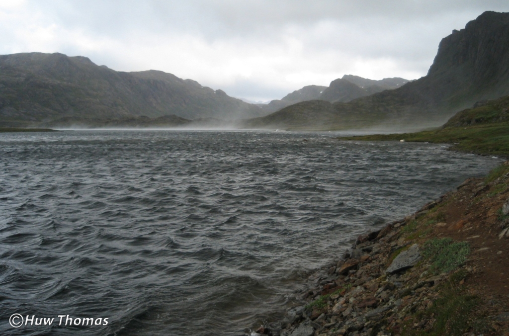
As I walked away from the hotel along the metalled road surface, I was initially very attentive to any adjustments needed to make the pack as comfortable as possible. At the appropriate point, I then slipped behind some buildings and took the dirt track road down to the water reservoir. Here, shortly after the end of the track, I was then faced with the treacherous rocky edge of the lake. Here I knew I had to proceed with great caution. The weight on my back made clambering safely over these jagged, tumbled boulders more challenging than normal so it was steady, slow, safe progress to ensure my start wasn’t also the finish from a twisted ankle or something worse!

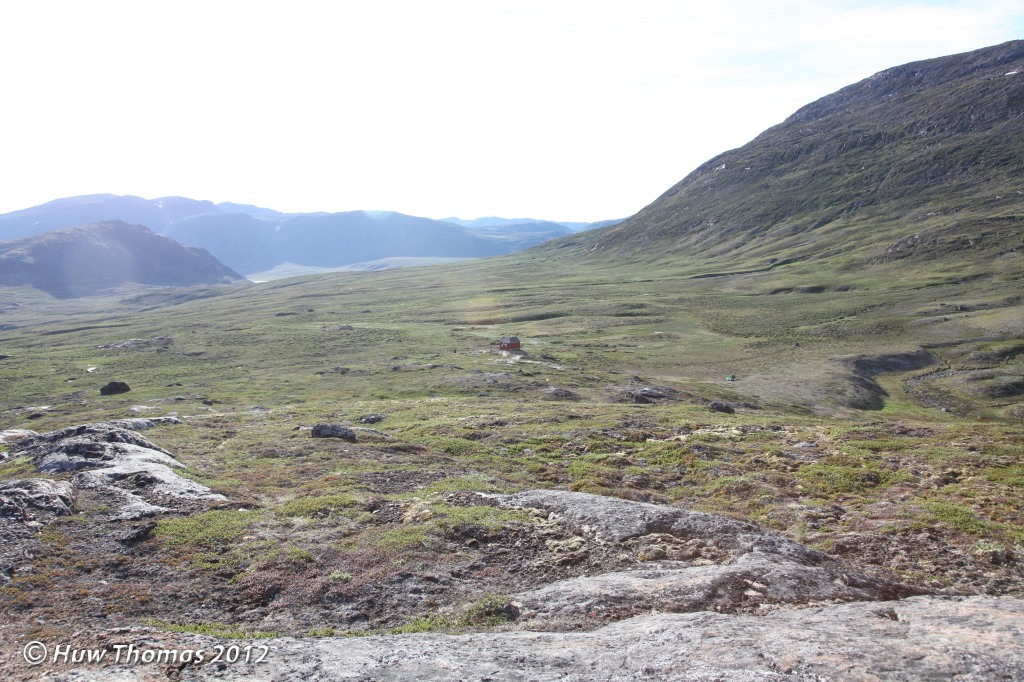
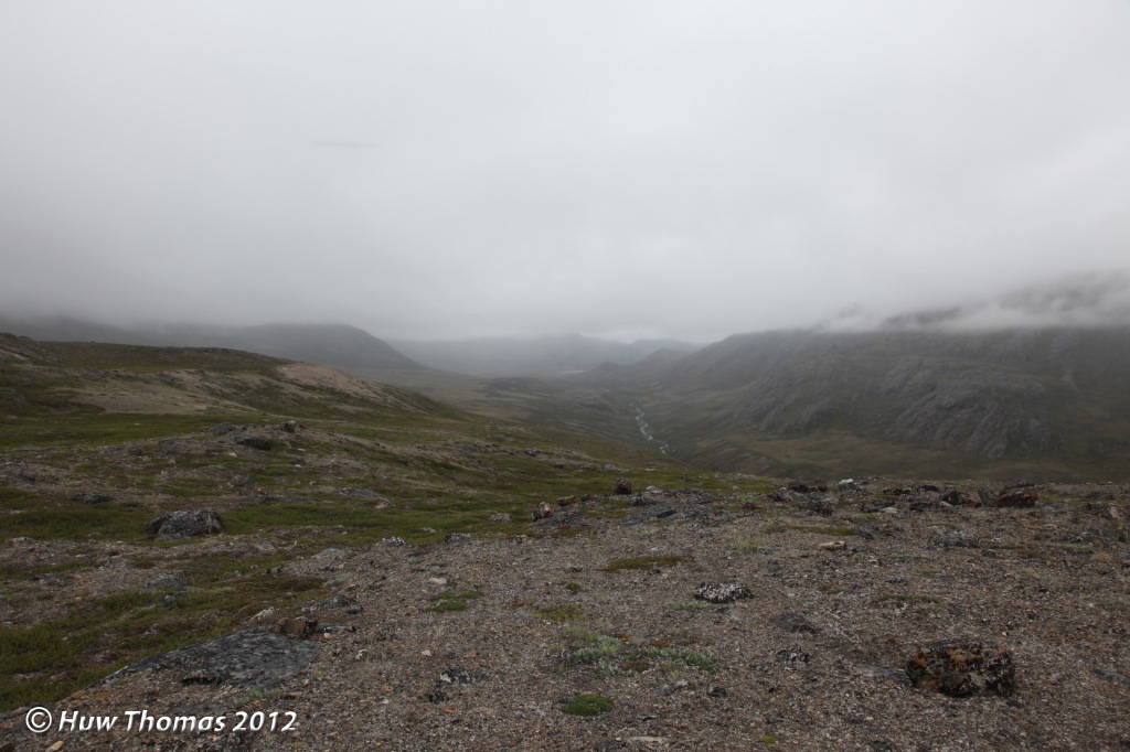
After negotiating that tricky passing of the lake, I was onto proper back country terrain and started the climb into what I call ‘dinosaur valley’. (On my first occasion here six years earlier, I found this valley so atmospheric in appearance and landform that it felt like I had arrived in the land that time forgot and would not have felt it out of place to see dinosaurs roaming in it! Slight reference to a favourite childhood movie there!). It was generally foggy as I climbed into the valley this time. While there wasn’t much of a view of the peaks, the mist fell and then lifted again to reveal a little more of the terrain once in a while, but the silence and atmosphere was just as palpable as before and I loved being back here and travelling alone.


I made my way up into and through the valley, past the ski lift and a familiar lake, across a river and not too long thereafter, I was at the western entrance to the Qerrortusup Majoriaa Pass. The climb into the Pass today was tough! It’s a fairly steep climb that usually takes me about 20 minutes max but with this pack it was very hard work, and again thank goodness for trekking poles to help ease how much work the legs had to do. With a few brief pauses for breath I eventually topped out and met a couple heading to Sisimiut with light packs. The thought did occur that if I do this again, it will be purely to follow the ACT to Kangerlussuaq and with a light pack of just what I need for 8 days…! (That was my ‘in protest’ thought at that moment…but then see 2014 and 2017!).


I had a brief rest at the top of the climb and then progressed into the Pass. The Pass is about 3 miles of fairly level walking through a watershed and on a fine day, I thoroughly enjoy walking through the Pass. I decided to lunch at a very nice spot by the river where my friend and I had camped in 2006 on our way back to Sisimiut. (I recalled him sitting there in the sunshine tending to some spectacular blisters by the river!). Today the weather was not so bright but still I liked this spot. After some flavoured Ainsley Harriott couscous and a large mug of tea I felt refreshed, I lifted the beast onto my back and set off again. Whilst the hard climb into the Pass had generated a moment of doubt whether I could lug this pack for over 100 miles, that doubt had now evaporated and I felt confident that I could do this. It was certainly a bit of a battle to get it on my back after every stop but each time my technique seemed to refine and it got easier until it I had it nailed.

Oddly one of my worries was whether the shoulder straps, especially the one I first use to lift the pack and sling it up onto a shoulder would continue to hold with such weight on it but it did. My Berghaus Bio-flex packs are not light in themselves, but they are sturdily made and over the years out there, I have repeatedly found that with them I can comfortably carry heavy loads a long way.

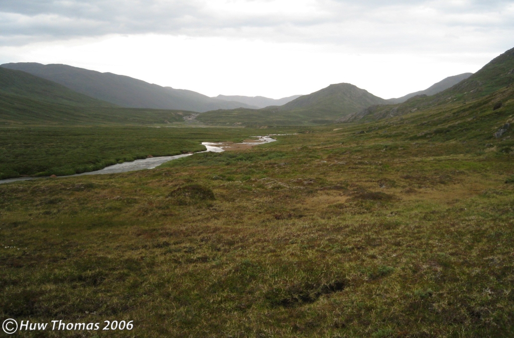
At the eastern end of the Pass, you face a long and fairly steep descent right down to the fjord. This took quite a while and going down was much more tricky and tiresome than climbing, it always seems to be so. Crossing the larger river at the bottom was also a little extra tricky as the slightest leap from rock to rock had to take into account the inertia of my heavy pack! Shortly after the river crossing, you reach the fjord and from the fjord, the trail then climbs steadily to the Kangerluarsuq Tulleq hut.

The Sisimiut map sheet is slightly misleading and appears to show the trail contouring eastwards on the hillside towards the hut but I have never found any such obvious route. The obvious trail descends right down to Kangerluarsuk Tulleq fjord and then, on days like this, offers you a long and in places very boggy slog up to the hut! This climb involves crossing narrow little streams crashing down the hillside and areas of wet soft ground where the rich, black peaty soil is exposed. Even though twice during the day I had used my Crocs to cross rivers, my Berghaus Explorer 4 boots had become soaked and waterlogged. I probably should have brought other boots but given the pack weight, I had opted for lighter weight boots. These had served me well in Scotland but perhaps were by now just a little too tired and beaten up for this trek!

That afternoon, I was pleased to see Kangerluarsuk Tulleq hut come into view. I was feeling a little tired by this point in the day and had a few slight aches thanks to my pack. So I was disappointed to see someone’s tent (a Hilleberg Akto) outside and a person nearby. Unless they simply preferred their tent, this could mean only one thing, and then sure enough, someone emerged from the hut…hmm! No hut for me this night then, though to be fair, I have stayed here several times before; including alone during my 2007 ACT trek when seriously strong winds arose that evening in which pitching a tent was a non-starter. That was a long day and I reached the hut at around 10pm having given up on where I had intended to camp for the night and pushed on knowing it was the only viable shelter. I recall the immense winds howled and gusted that night until about 3am and I was glad to be inside a solid structure, anchored to the rocks outside with solid steel cable!


It turned out there were four people in the hut that evening and as I was pitching my tent at about 18:30 in the little hollow to the west of it, it began to spit spot with rain, then it became quite a rain shower just as I got inside. According to my GPS unit, I had walked 12.9 miles today with a moving average speed of 2.2mph. This to me demonstrated the effect of this pack as my moving average out here over previous years is normally 2.6mph though I should take into account today’s climbing and the long descent from the Pass. Mosquito presence had been medium to heavy all day and I had been wearing my mosquito net pretty much all day. Despite the dampness however, it hadn’t been especially cold. It had been around 20 degrees C at 15:10 and was 18 degrees C inside my tent at 21:57.

Dinner was much delayed as the pump cup had become detached and was stuck at the bottom of the shaft of my stove pump. This was unexpected as I always service and test my stove at home before departure and it had been working fine so it was odd that it should develop a problem at the first use thereafter. Still you never know when something is going to go wrong. It took a good long while to retrieve the little rubber cup from the base of the shaft. I was desperately trying not score a groove in the plastic shaft with a metal tool as that would then prevent a good seal and render the pump much less effective. Eventually, I managed to retrieve the old cup which looked to be intact so assuming it had accidentally been popped off, I oiled it and refitted it but it came off again! So after retrieving it a second time a new one was required from my spares kit…then finally, dinner and a brew was on! After dinner, I wrote some notes about the day in my notebook and turned in for a sleep.
I awoke at 05:30 on Tuesday the 10th of July (day 2), dozed until 06:48 and had the feeling that it might even be sunny out there today! Over breakfast I made an assessment of the effectiveness of yesterday’s mosquitoes…a few stings on my right shoulder, some in a line across my neck and one on my left hand. All mildly irritating but nothing serious…I’ve had worse from this ‘occupational hazard’ out here! In 2009 for example, I was checking a lake with a team member who is a Collections staff member at the Natural History Museum of Denmark and was lying down in the vegetation gazing through my binoculars for quite some considerable time…when we were done, both of my elbows had more stings than the oldest and most used pin cushion!

Once away from the hut, I made my way along the relatively flat mile or so of terrain until the drop down to the lake appears. Depending on the line you choose from the hut, you may encounter some wet, boggy areas here but also a fairly large area of interesting vegetational mounds of pretty good size. Perhaps up to a couple of feet across and a foot or so high, I have also seen similar terrain elsewhere and it must be a curious set of circumstances that creates this? On reaching the top of the slope down to the lake I have often found myself swarmed by harmless but irritating little flies that love to investigate every orifice! I have had them in my eyes, up my nose, in my ears and have even unavoidably squished a few in my notebook! The thought of squashed fly guts in your ear is not a pleasant one! They were pretty intense again today which video footage I took clearly shows! So today also necessitated wearing my mosquito net all day again which is unfortunate as it does obscure your view and on warm days can feel a little stifling at times.

As usual, it took longer than new visitors might think to walk around the edge of the lake. Distances are often deceptive in such an open landscape, especially to newcomers who can be quite surprised to find that their objective seems to get no closer. I was amused to read in someone’s account once of walking from Katiffik hut to the Canoe Centre on Amitsorsuaq that they felt they walked all day while the lake seemed to go on forever…!

Having passed the lake, disturbed a ptarmigan hen in the willow and moved on further into the valley beyond, I came round a spur from the southern hillside and met a Greenlander from Sisimiut accompanied by a man and a woman. He said he’d done the trail many times but this was their first experience of it and they were heading for Sisimiut. Looking at the map he asked me about access to water at the Kangerluarsuk Tulleq hut which was a little surprising if he had done the trail many times. However, in very hot summers some of the streams shown on the map have very little water in them so you may have to check a few for a good source of running water.
After we parted, I had some good, obvious hard-surface trail and some ‘no trail’ which I was expecting as the terrain varies and gets a bit wet in places, particularly in between some large mounds. There’s enough boggy ground to squelch through if that’s your thing!
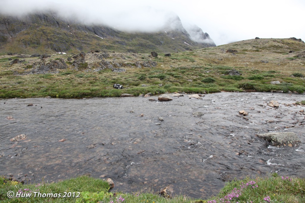
After a while I came to the first of three crossings of the same river. I knew the main trail well but also spotted a lesser trail leading off to the right along the southern side of the river. I wondered whether this might be a short cut so decided to explore it. I followed it for a while and then it became impassable amongst very large rocks. It became a tricky path in a narrow ravine with very steep sides and with the river deepening into dark pools. When I had to take my pack off and lift it separately to get over a large rock to see how things looked beyond I decided to go no further. I considered crossing the river right here but it was far too deep to risk it without what looked like a safe spot to try it so I headed back to the cairn and the standard river crossing point. It had cost me some time and effort but it was worth a look as you never know until you explore.

The first crossing poses a danger from lots of loose rocks in the river bed which can overturn or move and trap your feet enough to pull you off balance, while the second involves rock surfaces coated in that especially slippery brown algae. So as a solo traveller, I always take care to cross safely, without going over or suffering injury. So it was boots off, Crocs on, feet into refreshing cold water and steady as we go. It then isn’t far over that flat-topped area behind in the photo above to reach the second crossing and not long after that, I reached the tallest stand of dwarf willow on the official trail. It stands at about the height of a human and in the middle is a large boulder (erratic) with a small cairn on top. It may give you a hint of direction to head for if you try to keep it in sight but I have my own way of progressing through this patch of willow. It’s very tough wood but it flexes so it can easily catch your leg, encourage you to push against it but then eventually it gives no more and can trip you up. There is a lot more of this shrub elsewhere but this is the only remarkable stand of it along the ACT.

Eventually, having turned the corner into the Nerumaq valley proper, I could see the little red hut in the distance from about 2km (1.2 miles) away. It stands on a flat area above the river. It’s a pleasant level walk along the valley floor towards it but for those that are tired near the end of day 2 going east, again you may feel that it isn’t getting any closer for a good while.
The third crossing of the river is very close to the Nerumaq hut, opposite it in fact. The river is not very wide at this point and I managed to cross by rock-hopping with boots on. I then climbed up the short slope onto the flat area where the hut sits.

The Greenlandic woman I had met earlier in the day had told me that the Nerumaq hut was unusable because of a gap in the door that let all the mosquitoes in. So they had preferred to use the tent near the hut. The group also told me that some other hikers had left that hut that morning, heading for the next one eastwards. This was disappointing news about the door as I had hoped to use the hut tonight although it is fairly notorious anyway for there being a strong mosquito presence here in the summer. That’s certainly been my experience several times!
When I got to the hut, there were some mosquitoes inside but it was mostly the little flies again, which the Greenlanders had said they called the August mosquito? I set an insect coil alight and after some cooking too, their numbers had gone down appreciably, though it seemed numbers had abated somewhat outside too. I felt the hut was habitable and decided that I would sleep in it tonight. The door is a split door and the upper half had warped, leaving a gap through which the insects could enter so I jammed an old rag left in the hut into the gap and things seemed not so bad.
I noticed in the hikers book that there were some people from Manchester, UK here on the 27th of June who had written that this hut was the worst for mosquitoes…but having been here before, I turned in at 22:56 and was prepared to awake to swarms!
I had set off at 09:01 this morning and was intending to randomly note the temperatures as I made this trip. I had noted a temperature of 25 degrees C inside the tent at 06:57 this morning. At 11:05 the outside temperature was 23 degrees C but this rose to 27 degrees by 13:07.
On Wednesday the 11th of July (day 3) I awoke at about 02:00, I’m not quite sure why? The urge to get out of my bag and look out of the windows was irresistible and I found that the light outside was beautiful but it was too early to start the day so I went back to sleep until about 06:00!
At breakfast I ran through my food supplies and reaffirmed that I could make it run to 12 days if need be. That was a nice margin as I planned to venture into new territory…I could sit out bad days if need be or take my time to enjoy being in unfamiliar terrain. There was no need to rush along my new route!

Soon I was all packed up again and ready to go after sweeping the hut and making sure the door was properly closed. It’s important to leave the huts as you’d like to find them. From the Nerumaq hut, I headed to the corner of the left turn taken by the valley, turned the corner and came into the good long straight section of valley. The trail here has always been good and easy to follow and it was pleasant walking through this fine valley. For about 5.5km (3.4 miles) the trail made its undulating way up and down over some mounds in an easterly direction on the northern side of the valley until reaching the point at which it begins to climb.


Today was another sunny day, the air was still and there was barely a breath of breeze to cool me. Clouds of insects abounded practically all day so once again I had to wear my bug net for most of the day. On days like these, which are not that unusual in July, you sweat a lot…especially if you’re carrying a good sized pack and climbing slopes so hydration is important and wearing a bug net feels even more stifling.
Eventually, the trail began its climb at the far end of the valley, up onto a higher section where I passed a number of lakes to my right. I recalled camping here in 2006 with an exhausted partner who had largely ignored much of my advice before the trip and was now suffering. It was here overnight, while he was fast asleep, that I made the decision that he was in no fit state to finish the trek and that we should head back to Sisimiut. I broke the news to him in the morning. He was a little disappointed but mostly relieved…and still faced 3 days of hiking back to town with blisters that could win awards!

This upper section is about 6km (3.8 miles) long and pleasant walking. I noticed some old goose droppings at one of the lakes but no such birds. There were plenty of buntings accompanying me during the day, at least one Wheatear and I had heard a Raven somewhere down in the valley. It was up here in this section that I met a mixed bunch of six Greenlanders, adults and children, heading towards Sisimiut. We exchanged greetings and then continued on our separate ways. Eventually I reached the familiar section strewn with stones, picked my way along and came to what I call ‘flat rock’. This boulder is a nice spot to sit and enjoy the view from the high ground across the lake below, towards the Innajuattoq huts.

Apart from the ever-present insect company, it was easy walking down to the lake though the whole section takes longer than people would think. I knew I’d have a choice of two huts tonight, the newer and larger one which is on the lakeshore and the first one you come to after crossing the river; or the smaller, older one which is out of sight and further over the hill from the larger one.
The trail lakeshore was a mixture of dry and boggy sections and as I got closer to the hut, I could see there was someone there. Just before arriving at the hut, I knew I’d need to cross the river and I also knew there were two crossing options: boots-off just into the lake where it’s relatively shallow and before the river plunges through some deep sections, or further downstream, away from the lake where the river widens significantly but is fairly shallow for the most part. On this occasion, I opted for the wide shallow crossing. Since I was a child, spending a lot of time at Snowdonia’s lakes and rivers, I have always enjoyed crossing waterways by finding a viable way from stone to stone…often it was with a fishing rod in my hand and a trout hanging on a hook! It took a little while this time to evaluate possible lines and carefully pick my way but in the end I managed to get across the river without having to take my boots off.
I reached the hut at 17:00 and like any good cowboy would count the number of horses outside the saloon so that he knows how many guys are inside…I counted the number of pairs of boots outside the door! Inside I met four very friendly Greenlandic women. Quite naturally we got into very enjoyable discussions about the route, food, the goose work I was involved with and so forth. It was their first time on the ACT and I believe all four were from Nuuk. They had set out from Kangerlussuaq on Saturday so they would be right on the 8 day schedule if they were staying here tonight.

I noticed they were carrying a rifle and they said there had been three polar bears in the Nuuk region that year and that last year, there had been one sighted up in this region too. (I had also heard from another source that a bear had turned up near the harbour at Kangerlussuaq/Kellyville in 2011…perhaps that was what they were referring to?). I also learned from them that someone had now erected a footbridge over the river at Ole’s Lakseelv so that not everybody would have to wade across the river in the good old traditional way as I did in 2007. (Personally, I tend to regard that as a fun part of the ACT adventure as it is the deepest river crossing on the route but no doubt many will welcome the footbridge…).
We discussed the trail that lay ahead for them and they asked when did I expect to reach Kangerlussuaq? I explained that I wasn’t heading for Kangerlussuaq and that on the next day I planned to leave the ACT and head east by a very different route. They were quite surprised at this and said I was like a Qivittoq, a sort of mythical Greenlandic folklore character who lives alone out in the wilderness. I rather took that as quite a satisfactory compliment given my intentions! They said they had seen me coming along the lakeshore and thought I was running! I was pleased to hear that and clearly I was still managing something close to my normal pace on the trail in that case. After a while, and to my surprise, they started packing their gear and explained that they intended to push on a bit further this evening. So at 18:30 they made ready to depart and I watched one easily lift her pack up onto the table and put it on…if only mine were so easy I thought!
I had set out from the Nerumaq hut at 09:02 this morning and was pleased to arrive at Innajuattoq II at 17:00 as it would give me a good few hours with the pack off my back. I did consider taking Thursday as a rest day in this very nice hut, no doubt it would be welcome. When you’re in such a comfortable hut, with room to walk about, comfortable beds, a space to cook, a table to sit at and windows through which to enjoy such a fine view…your mind seems to look for reasons to stay a while. Perhaps especially when it knew this would be my last opportunity to enjoy the comforts of a hut. Mine was contemplating that my unknown route the next day may take me into tough unbroken ground, bogs etc that may be hard going so why not indulge in a rest day tomorrow…?

Meanwhile, I also wondered whether I might have the hut to myself this night? Anyone coming from Kangerlussuaq late in the day would see the old hut first and I hadn’t expected the women to depart this afternoon!

By 19:55 the sun was beating down warmly on the entrance side of the hut (northern side) and it was a lovely evening. I went to the river to fill up with water in a fast running sidestream and as I knelt down, I slipped on a rock surface covered with some of that treacherous brown algae. I lost my grip on my battered but trusty 2 ltr Sigg water bottle as my bodyweight caused me to twist and end up sitting on my backside in shallow water! My bottle was swiftly carried away by the stream and went under some large rocks hanging over a deep dark pool. In my Crocs I dashed over to the large and deep pool beyond and watched for it to emerge from under the rocks but it didn’t! Then from the upstream side I could just see the metallic blue colour of it in the frothing water and managed to carefully retrieve it from where it had become lodged under the rocks. It would not have been a complete disaster had I lost it but I was very pleased to retrieve it.
As I returned to the hut I could see that by now, the women were having a rest stop part way up the long slope at the western end of the valley. I wasn’t sure why exactly but I felt compelled to watch their progress until they were out of sight, maybe because with no other humans in sight, that would then become the moment at which I would be alone in all the landscape that I could see? At 20:21 they were having another rest stop nearly at the top of the climb. Shortly thereafter, through my binoculars, I watched their small figures disappear from view one by one and that was that…I wrote up my notes and settled in with the hut to myself for the night.
Thursday the 12th of July (day 4) started much like the day before, with mist clinging to the hilltops though it soon burned off yesterday. This morning I felt sure it wouldn’t shift so easily. There was a good breeze blowing across the lake from the west and it was cooler, 11 degrees C at 09:23, but also mosquito-free…for the moment.

So today wasn’t going to be a rest day at Innajuattoq II after all. I thought about it some more but in the end, decided to get on my way. I had taken a leisurely morning about it though and didn’t leave the hut until 11:00. Walking up and over the hill behind the hut I soon saw Innajuattoq I come into view looking forlorn and unloved since this larger hut was erected. It is the older and smaller hut but I confess I prefer the spaciousness and lighter interior of the newer hut, plus its more convenient proximity to a water source.
In 2007, having started at Kangerlussuaq, I arrived at Innajuattoq I in late afternoon. I was getting settled in for the night when four hikers arrived. A Dutchman and his two sons and a New Yorker they had picked up along the way. If you’ve seen inside the smaller huts, including this one, you would know five of us was going to be cozy but also, …they were smelly! No doubt not their default state(!) but the result of several warm days on the trail. I decided that I was not going to enjoy the ambience that night so politely surrendered the hut to them and said I would prefer to sleep in my tent. I grabbed my things and decided to go out of sight over the hill, perhaps nearer the lake to camp for the night, when suddenly I saw the newer and larger hut. It was a real surprise to me on my first time at this location because only the older hut was marked on the map. (The maps were all the guidance I had to the trail back then). So here was yet another hut not shown on the official maps! I investigated and found it to be empty and a much more attractive prospect for the night. However, I had barely sorted my stuff out inside when in the quest for water, one of the other group spotted it too and soon all five of us were in this hut! They were a nice enough bunch of people but it has just occurred to me as I write this that this episode might well be the reason why every time I have been here since, I always sleep in the main area and not in the back room with others in the bunk beds!
Leaving both huts behind on this day, I made my way around into the wide shallow bowl where sits the next lake and passing it often means crossing a boggy stretch of ground. I have walked around the drier base of the hills once but it did feel like quite a long way about it just to avoid the wet ground nearer the lake. At this point on the trail a hiker also transitions between map sheets. There are three sheets at 1:100,000 scale that cover the entire trail and in my case I transitioned here from the Sisimiut sheet onto the Pingu sheet (the middle map sheet) as this lake appears on both.

On this day, the trail soon then spends quite a bit of time going directly south alongside a large lake before skirting another couple of lakes and climbing up into the hills. It then continues east along the hill tops for about 3.5km (2.2 miles) before turning south again for about 2km (1.2 miles) above a ravine to the left that had a nice river in it when I first visited here. Since then the lake has been dammed off and the ravine is now dry. Eventually, the trail descends from the higher ground, crosses the old river bed and shortly after that, arrives at the Eqalugaarniarfik hut.
However, that was not my route today. This was the day on which I left the official trail to begin my own intended route east. When I reached that point on the trail I felt both excited to be starting to explore new terrain for myself in that wilderness and also very briefly, a puzzling little flash of slight anxiety? As I came to my departure point the slight tinge of anxiety was surprising and unexpected. After all, further east, I had in previous years wandered all over the terrain, far from any trails so being alone out there off-trail didn’t bother me in the slightest.
I examined this a bit. True that if you should have an accident or fall ill somewhere on the trail, sooner or later, someone is likely to come along but where I was about to go, I had no expectation that anyone would happen upon me…in fact, quite the opposite. I would be completely alone, out of sight from the trail. I was conscious of the fact that I had a long way to travel alone in very remote terrain that I had not seen before but given my activities further east I was not at all daunted by this prospect. Knowing how much I enjoyed wandering alone in the east, I quickly dismissed the feeling that stepping off the ACT was letting go of some kind of invisible ‘safety line’ as irrational sentimentality. I think that is all it was, just my mind registering that from this point there was a change in circumstances and from now on, it is up to me…
I did however want to note the precise location and the occasion with conscious thought given that here was the exciting point at which I stepped off the ACT to explore new terrain and to do so completely alone. Here at this very spot where I stepped away from a visible path well worn into the ground, and only the width of a pair of boots, was where my personal adventure for 2012 really began and that seemed worth a moment’s reflection and celebratory, or perhaps duly respectful observance!
When there is a very clear trail, very little thought is needed to walk along it. You just follow it from A to B to C and so on, but from this point, I would be constantly making decisions about my route through pathless unbroken ground. My mind would be much more occupied with my circumstances and my hike would become much more absorbing…rather like exploring the terrain in the east for the first time. I would pleasingly intensify my connection with the landscape by having to concentrate so much more on where I placed myself within it. I would no longer be simply following others while observing what the trail is leading me through, I would be making choices based on what I see all the while.
I walked away from the trail and it didn’t take long for the place to feel a little ‘alien’ as I left the familiarity and sense of human presence of the ACT behind me, but I was now committed and truly on my own. It may also be worth noting that once you step away from the trail, it is often completely invisible from even a short distance because it is so narrow and generally not a severely eroded mountain ‘highway’ as you might find in places in the UK. A short time later I saw my first hare of the year and as the landscape unfolded as I expected, I felt entirely comfortable with my plan. Any doubt quickly evaporated except for a nagging concern about an old injury in my left knee which occasionally gives me trouble when going down hill. I hoped not to aggravate that by choosing wisely and avoiding too much climbing and descending in the coming days with a pack of this weight.
Today had been generally cooler and I noted that at 16:08 the air temperature was 16 degrees C. Mosquito-free hadn’t been how the day unfolded in the end, there had been some out and the ‘August mosquitoes’ were about all day so once again I had to wear my mosquito net all day! I had also discovered over the last few days that my GPS unit was often off despite being certain that I had switched it on after a stop so undoubtedly my stats would be short of actual distance covered. Eventually I realised what the problem was and by packing a little tissue paper in the right place in the battery compartment, I felt confident I had fixed it. On the plus side though, after drinking stops on this day I was pleased to feel that getting my pack on my back was much less a challenge with my technique though it was still quite heavy.
I was now in rougher terrain with no very well trodden, nice firm trail. Progress was naturally a little slower, and after a while, the shoreline of a lake up ahead looked like it would be difficult passage so I climbed onto a hill nearby to pass behind the lake. From here I could see that to get into the valley I had in mind, I would have to start tomorrow with a climb. For now however, my day was ending at 18:58 and at least 42 miles from Sisimiut (subject to GPS data losses!).
Picking a spot to place my tent was a little tricky and I ended up spending a good while clearing stones from an area large enough and making sure no protruding stone or root was going to pose a threat to my groundsheet…even though I also use a footprint.
By the time dinner was ready, I thoroughly enjoyed the first of the “Trek’n’Eat” meals I had brought. Spicy beef casserole with noodles and very good it was too. I also fully approved of starting off with a hot soup to reawaken the taste buds, introduce warmth quickly and help with re-hydration.
I was pretty clear that the weight of the birding optics made this hike tougher than usual, especially now that I would have no easy trail to follow. Normally in the east, I would be carrying them in a day sack with just what I need to be away from a static camp for the day but here I was carrying them with everything else; including 12 days of food supplies and a sturdy 2 person tent so that I would have a decent amount of habitable space for 3 weeks when I arrived in the east and set up a static camp. It would have been very disappointing though to find any of our birds along this route and be unable to identify individuals for want of decent optics.
Tonight I had tens of dipterans in the tent and a few mosquitoes so I decided to try a new technique. I opened a gap in the mesh at one entrance and lit a cigar at the other…sure enough, I had them all out in about 5 minutes. Easy to justify bringing a few cigars then and a benefit of my preference for two-entrance tents for summer in Greenland!
On Friday morning, the 13th of July (day 5), it felt cool inside the tent though it was about 17 degrees C. I had been awake at 04:30 but then dozed until 07:45. Initially there were no insects about and it was foggy outside with a mist coming up the valley behind me. But it soon began to lift and then my winged companions were back!
I got away at 10:03 and as I had seen the previous evening, the day began with a relatively short but stiff climb. After a while of topping out…in other words, reaching what I thought was the top of the climb…several times(!), I came to the area I was looking for and was glad that the mist had lifted a bit. It was hanging about at the height of the hilltops so I was able to see the terrain ahead. It was fairly undulating terrain with lots of knolls and dips so had I been trying to walk on a bearing in the mist, I could have been doing a lot of unnecessary climbing and descending but as it was, I could pick my way amongst them…there being no trail to follow of course! On a nearby lake I was delighted to see a pair of Great Northern Divers and on another lake a Mallard drake and two hens. After a few kilometres, I reached a point with lower ground before me, sloping away for a couple of kilometres. Beyond that and up again at similar height to where I was standing, I could see the lakes I had intended to reach today…and they did look a fair distance away.

As I had expected, my chosen route occasionally needed slight adjustment when ground-truthed visually in the real world, but as the day progressed I was very happy with it and thought my home-plotted route worked very well. My journey was unfolding much as I had expected it to and the joy was in seeing the terrain for real. I descended into the low ground where there was a cluster of lakes, channels and some wet ground…with no pre-existing trail to do the thinking for you…I was thoroughly enjoying making my own decisions. My mind was now truly enjoying the constant engagement of reading the landscape, assessing the terrain and deciding which way I would go, where exactly I would walk, what feature I would aim for, where it places me for my route options ahead. So here, at this point, I had to decide which way to get past these lakes which might not necessarily be the way I had anticipated when pondering the maps at home. I also knew that during this hike generally I may need to be prepared to double-back or try another way if it became necessary…or to look back and see that there was a better route had I known!
After passing the cluster of lakes and while climbing back up to the higher ground I noticed an attractive river channel and small cascade off to my right and it made me stop to regard it…and listen to its sound as the only thing breaking the vast silence. It seemed like the pure music of nature. I was struck by the thought that here is a very remote spot on the face of the planet, not especially spectacular by global standards, in fact quite ordinary in one way but special enough to me because of its remoteness and where in the world it was. Here, by gift of nature and natural processes, a lovely pure river flows through its channel day after day while the ‘world’ is completely unaware of its solitary song. How many people will ever stand here, hear it and bear witness to it? When I am back home, this river will still be flowing here in this very place…day and night (except for winter!)…and I will know it is there, none of my fellow humans at home will and in all probability, there might be no human person here to appreciate this place or acknowledge that it exists at all… These unbidden moments and these kinds of thoughts are part of my personal exploration of solitude and isolation out here. They are part of how I experience both when I am alone in Greenland’s wilderness and how I discover and appreciate what really matters to me about being alive in this world…I sense it and revel in it when I am out here and not distracted by the daily necessities, noise and concerns of the kind of living I was born into.

After a while of pleasant thoughtful reflection in perfect solitude by this river I moved on and saw my second hare and my first White-tailed eagle of the year. The eagle was soaring west to east directly above the lakes. I also came across a nice lively, fairly wide river that needed crossing and while removing my boots I noticed that some stitching was coming undone at the upper inside of my right boot. I made a mental note to have a good look at it later.
Back on the upper ground, I made good progress on a firm surface and eventually chose a spot to camp for the night. It can be surprising sometimes how long you can spend looking for the ideal spot to pitch your tent in such vast wilderness! First I saw what looked like a nice spot but it turned out to be flat rock surfaces so no purchase for the tent. The next spot had room for the footprint pegs but would have had me side-on to the wind. So I settled on a patch of knobbly but spongy dry heath in a little hollow facing a small lake and had to use stones for most of the guy-lines – the ground being unsuitable for pegs to get a firm purchase. Tonight would be my first pitch in new terrain for this year and out here now, I could certainly feel that powerful sense of being alone and far from everyone being amplified by the unfamiliarity of my surroundings.

On checking my boot that evening I found that the inner lining was fine and that the seam was not readily unstitching itself. It seemed to have frayed a bit where the boot bends as I walk so I would keep an eye on it. I did check my sewing kit and should I have need, I found the big needle…the one “Mitch” used in 2010 to make moccasins from the muskox hide he’d blagged from a local hunter.

He’d arrived (from the US) for his first visit to Greenland and several weeks of fieldwork with no camp shoes and while at Kangerlussuaq campsite for a few days waiting for news of the helicopter, we embarked on this venture. The basic design of the first was fine but the manufacturing process let it down a bit. Still, with enough hide left for a second one and “Mitch” having more production experience, the second was much more impressive! In fact, they fitted quite well, they lasted him all the weeks we spent out in camp during the month of May as I showed him around the territory and he swore they were very warm on his feet in those cold evenings. I do recall he would shuffle around in them with oversized feet looking rather like a classic depiction of Frankenstein’s monster…but there was no denying that they were functional…and being hand-made from a local animal hide only recently hunted, they possessed a certain charm and authenticity!

I don’t quite know how it had happened but I found that the needle in my kit was snapped in two? I had another of that size but still I thought it would actually be a heck of a job to try stitching up the boot without breaking that needle, especially while trying to pierce from the inside…it had certainly been very hard pushing the other one through the muskox hide so many times because it became coated in oils and resins from the hide and became quite sticky.
By 21:00 it was windy outside and 16 degrees C inside the tent. When I was settled with a coffee I set about penning some thoughts about the day…including recalling how I had been checked out by a dark coloured fox a little earlier this evening and that at 22:01, I noted the air was now completely still outside. As I sat in my tent with the dark figure of a large mountain to the north of me…now apparently 49.9 miles from Sisimiut, I closed my notes with the words: “The silence out here is amazing every time…”.
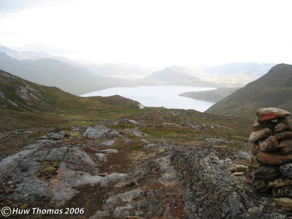
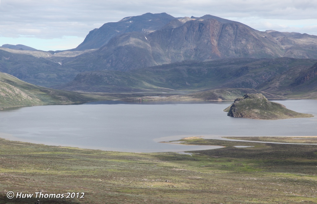
Saturday the 14th of July (day 6) opened with a grey morning, no sign of blue sky anywhere. It was 18 degrees C inside the tent at 06:48. I made a good early start today I thought, leaving camp at 08:21. Shortly, I had made my way over to the edge of the high ground and enjoyed spectacular views of Tasersuaq from the 300+m (984+ foot) cliffs above its northern shore. At about 19 miles long, this is the largest lake in this area though not the only one to go by that name. The official trail, the ACT, glances a blow to a large bay on its southern shore and views of the lake and these cliffs are enjoyed from the high ground heading towards Ikkattooq hut, but even from that high ground, it’s not possible to see all the way to the far (eastern) end of the lake.

The going up here was good and firm much of the time though a lot of rock exposures were well weathered and quite friable. I made good use of the whaleback rock exposures to enjoy the traction and the scarce feeling of solid ground under my boots. Mentally plotting my route ahead as I walked, I veered my route this way and that to avoid unnecessary dipping and climbing back up from lower points in the terrain. The weather was not encouraging, the entire sky, (which out here is expansive!), seemed blanketed in thick, heavy, immovable grey cloud. At one point I began to suspect that I had rain ahead of me and was keen to get to lower ground in case the mists descended to 300m or below. Navigating my route up here in this terrain in poor visibility would be horrid and I could not so easily pick my way along the most level and least demanding route. The maps tell you roughly what to expect in the landscape but at 1:100,000 scale with 25m contours, there are countless smaller hills and hollows that are not much resolved on the maps but are enough to make you work hard over a day so being able to see the ground before you makes for much better route picking.

The dipterans (August mosquitoes) abounded in great numbers all day so my bug net was on yet again and my map and notebook became the final resting place for several because they simply got everywhere, even inside my pockets!
After about 4.5km (2.8 miles) I came to the head of a wide and gently sloping valley. I stopped to take some photographs and realised that I no longer had my bug net on my hat. It is an essential piece of kit out here of course, your protection against some serious and prolonged misery! I did think that depending on how far back it had fallen off, my chances of finding it up here might be slim. Although I carry a spare in Greenland, I was loathe to lose it. So I left my pack and decided to backtrack for a while to look for it. I am fairly good at remembering which way I have come through terrain like this but I used the Track feature on my GPS unit for maximum accuracy. Happily, I found my bug net lying on the ground a couple of hundred metres back behind a rock I had sat on while drinking some water. Naturally, I had lifted it up onto the hat to drink and then not been prompted by sufficient bug interest at that moment to pull it down again.
I returned to my pack, saddled up and after a good scan of the terrain, chose the line I would take down this valley. It was a gentle descent for about 3km (1.9 miles) generally walking on soft vegetation most of the time. Rough terrain out there can make walking challenging at times. What is underfoot is natural of course, it has not been disturbed nor compacted from regular footfall and is subject to extremes of weather and conditions. It is not always nice and flat! Each footfall can be unpredictable in terms of whether you will hit firm ground at the same height as the previous step…or above it or below. At times out there, you can feel like you are more lurching about than walking in any normally choreographed or elegant sense! A key difference from happily yomping along a nice compacted ACT!
Nevertheless, it was very enjoyable to be going gently down hill with this weight on my back for a good long while. By the time I reached the eastern end of the valley, I had seen another hare and one raven and then I came to a river about 30 feet wide, fast flowing and deep in places. After choosing a crossing place and executing my usual routine, my Crocs saw me across with my trousers rolled up and everything dry. There was something very satisfying in a mild sort of adventurous way about tackling these obstacles, drying off, getting my boots back on and setting off again on my way while being entirely alone and so far from anyone. To be out there feeling entirely confident, thoroughly enjoying what I was doing and not feeling the slightest bit lonely in my solitude fed my personal sense of self-reliance and resilience.

It was amusing sometimes to contrast my location and what I was doing with what friends and work colleagues back home were very likely doing in their normal daily routines…the willingness to put myself in this position, to venture off alone into the wilderness, felt quite exhilarating. Most of my friends and acquaintances at home say this kind of thing sounds like hell and they certainly would not want to endure such a miserable and physically demanding thing. Every single one says they could not face such solitude in the wild and so remotely. It’s most definitely not their idea of a holiday! But that in a way, makes my experiences out here even more precious to me. Whilst not epic on a polar journey or Himalayan scale, this was both challenging and rewarding to me, partly physically but mostly mentally, in a most deeply personal and satisfactory way. I find it a source of mental strength and wellbeing to know that you could drop me out in this remote place entirely alone and I would be perfectly happy to make my way with just my own company.
After the river crossing I came to a lake where I found another Great Northern Diver. These beautiful birds are one of my favourites of all out here, particularly for their range of haunting sounds. Their calls are such an iconic and unmistakable sound of the wild that I love to hear them out there. The calls of Divers seem to underline and emphasise that at that moment, I am truly privileged to be alone in such an enormous area of pure wilderness, nature essentially unspoilt by my own kind.
I had reached the lake at 13:00 and was very pleased with the morning’s progress which had been a little better than I had anticipated. Clearly I had half a day left yet so would not be contemplating stopping here for the day. I pushed on past several more lakes, including another with a Diver on it (or possibly the same one still curious about me?). There was some boggy ground to traverse and then I came to a lake where my home route planning had offered two possible options in the landscape. One was to turn east then eventually south, the other to head south then turn east. Both were attractive options now that I was standing there and looking at the terrain in real life but in the end I decided to head up the valley behind (south) of the lake and later turn east.

This was a sweet little valley in which sat a pair of very attractive small lakes, quite modest in fact considering the size of the company they keep in the wider landscape but they sat in a beautiful setting. As I passed the second one, the land began to fall away, the sides of this little valley peeled away and the view opened out across Tasersuaq and to the lands beyond in the south. It was like emerging onto a natural balcony in this big beautiful landscape. The weather had improved a bit and from here I had a clear view of the section of the ACT that goes past Kangerluatsiarsuaq bay but I could not make out anybody on the trail with my binoculars. It was now 16:00 so the question was whether to spend the night at this very nice spot or push on a little further? I decided to move on a bit further to some target lakes after a good look at the map and then at the landscape to visually picture roughly where they would be and what line I would take to reach them.


It turned out to be another couple of hours of picking my way along through unfamiliar terrain and it was some time before the lakes I was looking for appeared in the landscape. At 18:15 I had reached the lakes I had in mind and decided to camp on some ground between them. According to my GPS unit, I was now some 99km (61.5 miles) along my route.

Conditions had turned a bit gloomy again as evening wore on. I pitched my green Terra Nova tent for the night though I don’t precisely recall whether it was the Ultra Quasar or Superlite Quasar I had taken with me on this occasion. Both are good for this terrain and I prefer to have geodesic tents with entrances at both ends out here. There are days in static camp for the wild birds work that can get very hot and being able to effectively ventilate while keeping the mosquitoes out is most welcome.
My starter this evening was another hot cup of soup with another chopped fresh garlic clove thrown in, followed by a very tasty dinner which was sweet and sour chicken with rice by Mountain House. Another cigar and air passing through the tent had been effective again at clearing out most of the winged pests and by 20:57 I was sitting comfortably listening to one of my favourite sounds out there, the calls of a Great Northern Diver on the lake behind me. I then heard a fox calling somewhere nearby and noticed the air, and the lakes, had become perfectly still. In my notebook I wrote: “Everything is serenely calm now with just the Diver and the occasional flutter of a grey moth’s wings on my flysheet.”

Each evening of course, I reviewed the route on my map, relating what was on the map to how the terrain had turned out to be and reflecting on any variations I had made; but in particular I also need to look at the day ahead. From what I’d seen on arrival, tomorrow’s start wasn’t quite what I had envisaged…between the contours, the initial climb from the lakes looked steeper than I had hoped for. So I considered whether I would tackle that climb or take a longer, gentler route to gain the necessary height? I stepped out to look at the surrounding hills so that I could assess possible lines. There were fewer good looking water sources along my route for a while tomorrow so I would need to be happy with my choice of route. This daily assessment of options on the map and deciding on my line is very satisfying and feels like another manifestation of the freedom I have when there is no compulsion to adhere to a trail.
An hour later though at 21:52 a slight breeze was attempting to pick up and the Diver was either roosting or had cleared off. With thoughts of tomorrow on my mind, I took a look at the sky. Cloudy, it didn’t look good to the north as had been the case for days. There was some brightness in the far distant west and things looked a little more broken up in the east with some patches of blue sky. I tuned in without high expectations of the weather again tomorrow which was a pity because it’s an entirely different feeling here on those big blue sky days.
Sunday the 15th of July (day 7). This morning I awoke and to my pleasant surprise could feel the telltale warmth in the tent of a better day outside. At 06:54 it was 24 degrees C inside the tent…that would do nicely! There was a pair of Divers calling on the lake behind me…my early morning equivalent of a cockerel but so much a sweeter sound to wake up to! As I turned in last night I was very surprised by how extensively the mozzies had got my legs, my right leg in particular. I couldn’t quite understand when they had had the opportunity, maybe during river crossings(?), but they had blitzed me somewhere along the route and it had itched quite a bit last night in the warmth of my sleeping bag! My attitude remains though that they are an occupational hazard out here and you just have to tolerate it. I had tried a new mosquito repellent with powerful advertising and dramatic claims…but just as before, I find them largely ineffective…especially on hot days when you have sweated them off in no time.
Today I decided to switch back to my Montane Terra trousers and my long-standing favourite black micro fleece out here, my Craghopper trousers being just too warm for a hot sunny day’s labours. (My favourite microfleece top is something of a fixture in my kit out here having been with me on every occasion prior to this and every occasion since. It is just the right thickness (weight) over a base layer to keep the mozzies off and without overheating me. It has had a few stitches over time around the cuffs but will remain my favourite out here I think until it is no longer wearable!).
The day started with perfect weather, blue skies, a light breeze and very low mozzie count. In this better light I could see that my original planned route wasn’t so tough a prospect after all and was quite do-able. It was nice to know that my original planning was holding true. That said, the day did start with 100m of climbing in two stages. This was nice terrain though and after the first climb, I eventually topped out and at a small lake I found a piece of a large eggshell, very likely a goose egg I thought. About half a kilometre later I came to the next climb and saw before me a curious feature. A strip of land running between two small lakes and onwards up the hillside…I’m sure its origin lies in a sill or dyke exposure perhaps but I called it “the Causeway”. It certainly offered the most appealing route to the higher ground so that’s the route I took. For some reason I didn’t photograph this place in 2012 but I did on a beautiful day in 2014 so that will be another story…

Once onto the higher ground at around 400m, I had views of Tasersuaq again. The fact that I had sightings of the lake during several days was a reminder of its very significant length. The terrain up here though was fairly demanding at times, very undulating with largely unavoidable dips and peaks but I was glad of the much improved weather which brings a little more joy with it. In poor visibility, this was another section where I had anticipated that adhering to a predetermined route would be challenging. There is little by way of an obvious line to follow so one has to stay focussed on direction of travel and picking your way amongst these hills.

In the early afternoon I noted that it was 25 degrees C at 13:24 and I was largely taking an instinctive line amongst, up and over the hills looking for a particular lake and was delighted when I came upon it nestled in a shallow depression in the terrain. I like to think that I have developed some kind of instinct for this terrain from all my wanderings out east but that may be simple romanticism! At this lake, I was now at least 7 or 8km from this morning’s camp. Here, as I stopped for water I saw my first cranefly of the year. This lake was a target because it was a particular node if you like in my personal route. From this lake I planned to descend into lower ground and as I walked to the edge of the hillside, the land below opened up as expected and had the anticipated cluster of lakes in the middle and a distinctive rounded hill standing sentinel to the west. From the bowl below where lay the lakes, there were quite a number of attractive route options and I again considered one in particular I had pondered at home but in the end decided it would add too much time to my hike and so I stuck to my plan.
Choosing my line, I descended the hillside and made for the lakes. Crossing the outflow behind the lakes was a little tricky…the terrain being tumbled rocks, a multitude of small channels and holes and depressions obscured by vegetation. A boot could happily disappear down one of these holes at an awkward angle! Happily though I spotted a little Red-necked phalarope in the outflow channel and a caribou off in the distance. I had also met another two hares today. I then pushed on across the low ground and into a small valley where at a small lake I found lots of goose faeces but it was old, lots of scattered downy feathers also lay around as well as some larger flight feathers. I suspected a goose had nested here some time ago though the nest was no longer obvious and very likely it would have been a Canada goose. At the water’s edge I also found my first bogbean plant of the year. Not a lot of it but nice to see its distinctive leaves swaying gently in the breeze.

By mid-afternoon my left knee was giving me some trouble so as I exited the little valley and a very nice lake presented itself below, I decided this would make a lovely place to spend the night. In subsequent years, this place was to become a regular favourite camping site on this route. The western shore of the lake would soon be in shadow but on the eastern side I saw what looked like a raised bit of open ground and headed for that. It was a perfect spot to pitch the tent…a nice dry, almost bare soil platform with just a little vegetation set about a metre above the lake’s surface and right beside it. So I ended today’s hiking at 16:17 and got the tent out.
It was only a short hop down to the ‘clean’ lake shore for water, the shore being lined with a ring of washed boulders and smaller pebbles. By 18:38 I was relaxing in my tent on a lovely evening. Both ends of the tent were open for ventilation but still it was a pleasant 23 degrees C inside. According to my GPS unit, I was now 112.6km (70 miles) from my start point in Sisimiut. Two days ago I had changed the batteries in the unit which had lasted for 28 hours and 25 minutes of moving time (not including stopped time).

For emergencies (and on this occasion to enable any necessary contact with my goose research colleagues should something go awry or if they decided to set up camp elsewhere than originally agreed) I carried an Iridium satellite phone. But to preserve my isolation from the world of human affairs, I save its battery power for such necessary use and generally avoid contact with home to keep myself off-grid! I was curious by now however to know whether there was any news of my colleagues and this evening when I switched the phone on noticed I had a message from another Iridium phone. It was from my friend and leader of the goose field work to say he and the small team for this year had arrived at Kangerlussuaq. I wasn’t entirely sure when that had been sent but replied to say that I was glad they had arrived safely, that I was not yet on the final map sheet and expected to find them in a few days if their plans were unchanged.
At 20:13 dinner was over, a few chores were done and I had been laying down wearing just a baselayer on my upper half and almost fell asleep in the warmth. Both ends of the tent were still open except for the mozzie mesh of course, and it was now 27 degrees C inside. There was a light breeze outside and very few mosquitoes. I had had my mozzie net up on my hat most of today which was very pleasant for better visibility and you could feel any breath of wind on your face.
In my last entry for the day I was reflecting on this being my last night on the Pingu map sheet and how wonderful it was to spend time in this huge unspoilt landscape, on its rocky ridges, in its remote quiet valleys and alongside its crystal clear lakes and rivers. I felt privileged to be somewhere that relatively few people will visit and experience. I closed with: “Strange to think it’s now 20:59 and the sun is blazing high… in the north western sky!“
Monday the 16th of July (day 8): I awoke this morning to a Great Northern Diver and a Mallard on the lake. The weather was good again and I made an early start, leaving this pleasant camp at 08:20. On emerging from the little valley containing the lake, the terrain opened out quite expansively. I had a pretty strong instinct where to head for though of course there was nothing obvious, like a trail or a cairn, to suggest where my personal chosen route lay in the landscape. Why would there be? My linear need to travel mattered nothing to this landscape which was itself an entirety, a natural whole in every direction. Choices presented themselves in this place again so I started off up a spur of land thinking I could steadily gain height on a hard slope but I later felt it was taking me a little too far off my intended line and adjusted my course.
So under another sunny blue sky that was relatively mosquito-free, I enjoyed seeing this unfamiliar landscape unfold as I climbed over its hills. In a strange way, the sheer pleasure of it felt a bit like unwrapping a secret gift that was for me alone. Eventually I came to another lake and having given up on any expectation of finding wild geese until I was close to the study area in the east, I was a little surprised to find not only a pair of Mallards on this lake but at the far end also a pair of Canada geese. For the first time since starting on this route, I dropped my pack set up the tripod and mounted my scope…and confirmed they were unmarked so not birds we had had in hand before. It was interesting to note though how far west I had encountered my first geese.
From here I continued my descent towards another lake through lovely arctic vegetation and beyond I could see where my route lay for several kilometres. At 11:29 the temperature was 25 degrees C.

Today’s route involved crossing a beautiful silent river flowing mid-thigh deep at the point where I met it. I came upon it suddenly as there had been no sound of rushing water from it. It was a very attractive river channel that seemed to be snaking quietly and smoothly through the land. The substrate looked soft and vegetated so I dropped my pack and in my Crocs and using my walking poles, I explored the substrate carefully to see how firm it was underfoot and whether I might sink deeply into soft mud with a heavy pack on my back! I found a point where the substrate felt fairly firm and my feet did not sink into it too deeply. I gave this river my confidence at this point as suitable for crossing and I took my camera, boots and GPS across first, then returned for the main pack. The time spent in the cool water was quite welcome on this warm day.

Not long after the river crossing I came to a large expanse of very dense dwarf willow which made progress slow and quite hard work. Anyone out here will find short sections challenging, even irritating, but more remote from the official trail, expansive areas can require a lot of patience and use a lot of energy to get through! I came upon a lake and found another solitary Great Northern Diver, and then, after doing considerable more battle with the willow, I reached another lake with a Diver on it though I strongly suspected it was the same bird! At this lake it seemed appropriate to stop for lunch and pause for another moment to take in my pleasing situation with all my senses…
Some time after lunch I knew I had to push on and was presented with several route options again in the terrain ahead. I aimed for one of several indistinct high points in front of me and after that faced a tumbled and very undulating landscape so that I could not see my way very far ahead at all. I had transitioned now onto my third map sheet, the Kangerlussuaq map sheet. When I arrived at the next lake, somewhat unusually, I found it was certainly not an appealing lake to camp by. The lake margins were deep in fetid and rank moss and algae, a bloom of some kind and its muddy margins a little smelly. All perfectly natural but thankfully this was not my target for the day and I pushed on to the lake I had preordained for tonight’s camp. It was quite slow and awkward walking alongside this lake as the hillside consisted mainly of large mounds with deep depressions between them and always there is the risk of hidden holes covered in vegetation, especially it seems where large rocks are embedded in the terrain. On my way there I had seen another Mallard on a small lake and three arctic hares at the western end of my destination lake. By the time I saw the hares as I emerged from a dip, they scattered too quickly for photographing. A pleasant surprise for me was an unpleasant surprise for them!
I reached the eastern end of the lake and made camp for the night very close to lakeshore on a patch of exposed stony soil. This was the only real option given the nature of the surrounding terrain where a level patch that could accommodate a tent was not easy to find. As before, I spent quite a bit of time clearing any jagged little stones aside, laying my footprint on the ground and checking it by hand for any potentially problematic protrusions.
Dinner was one of my ‘tuna specials’ tonight. So that would be pasta, a stock cube, a finely chopped garlic clove and a foil sachet of tuna in a flavoured sauce…very nice and chunks of tuna rather than rehydrated chicken or beef pieces were very tasty indeed.
I had set off at 8:20 this morning and stopped at 18:00. According to my GPS unit I was now 133km (82.6 miles) from my starting point in Sisimiut. At 21:01 I was joined by a Great Northern Diver on the lake…always most welcome company. Clouds were coming over from the north and it was a cooler 17 degrees C inside the tent, a little colder in the wind outside. During this hike, I had been rationing my bar of Cadbury’s Old Jamaica Rum chocolate but this morning I found it had become a gooey mess inside a sealed plastic bag, I was glad I stored it like that! Tonight I hoped it would solidify enough to offer solid chunks tomorrow!
Tuesday the 17th of July (day 9): another bright sunny blue sky day welcomed me on my ninth morning. A fairly relaxed start and I left camp at 9:40, walking up to a gap in the hillside behind my camp to look at what lay beyond. Checking my way forward I ended up walking/battling my way uphill through more birch and willow than I expected which meant I was soon sweating in this weather. After a couple of kilometres amongst the vegetation, I crested the hilltop eventually to see a fine lake in front of me. The setting was lovely, enhanced of course by the weather and since there was no trail inviting me to follow, I regarded both the northern and southern shores and debated which way to go?
For a while I just stood and drank in the beauty of being out here in silent, pristine nature. Being alone and silent in my own passing, and so insignificant in my footprint, I felt happy that I presented no disturbance; no significant incongruence or intrusion in this natural setting. It was pleasing to think that being entirely alone with no other distraction, I could deeply appreciate the sheer pleasure of being here while leaving no mark. I felt a strong sense of responsibility to leave practically no trace of my passing. I should absorb all the pure joy of the experience and go quietly on my way leaving it respectfully undisturbed.

Walking lakeshore the entire way on the southern side (right in the photograph) was clearly not possible, it was less easy to tell from here about that spur on the northern side? In the end, I opted for the northern shore but later found that a short stretch proved impossible to walk lakeshore so I had to climb up and over the spur. During this climb there was one point at which I had to take my pack off and place it on a ledge above me with my trekking poles, and then climb up there before I could continue. A short while later whilst back by the lake I found a Great Northern Diver on the lake with two chicks…tiny little black balls of fluff destined to grow up into impressive adult birds.
I appear to have forgotten to note the temperatures on this day but it was hot! I did note that at 18:55 that evening, after I had made camp, it was 24 degrees C outside. On these days, I have developed the practice of regularly dipping my Tilley hat in water to do two things…keep the sweat that permeates from the headband through the hat from permanently staining, and secondly the wet hat cools my head. I also tend to hang a small hand towel from my hip belt or chest strap so that it is within easy reach to wipe the sweat away. People might scarcely believe that in summer the days can be so hot out here that the sweat readily trickles down into your eyes!
After several more kilometres through this delightful terrain on this stunning day, including the joy of coming across many more Divers, both in pairs and alone, I found myself working harder through some difficult ground consisting of a lot of soft and uneven marsh while passing between two lakes. My original plan had been to walk around them to the north and perhaps that might have been a better route but when ‘wild walking’ one has the frequent opportunity to make instant decisions on which way to go. After reaching the small toe of a larger ridge, I stopped for a pleasant lunch.
On days like these, sitting all by myself in the warm sunlight, feeling gratefully far removed from the human world, cradled by exuberant nature, it can be difficult to peel away from thoughtful reflections and get moving again! Here amongst the wildlife, the vibrant plants and crystal clear waters with not a single artificial or man-made mark on the land, and surrounded by the soothing silence, I am often struck by the thought of this is how beautiful pure nature is! This is what it does, this is what it creates when left alone. This is how subtly and deeply it nourishes the soul if you open your mind and allow the reconnection. My species has done, and is still doing, untold damage to nature all over this world but here for a while I find myself in my personal Eden.
When I wander in West Greenland’s wilderness, I know that somewhere else far away from this unspoilt tranquil place species are being massively and unsustainably exploited, animals are suffering cruelty and brutality, forests are being felled and oceans are being polluted with plastic and other stuff. When I contrast what I know humanity is doing every day with the peace I find out here, I sometimes feel unworthy of the joy it brings me and that I should pass through this landscape with my head bowed in shame. This sense of reconnection and recalibration with the natural world is something precious that I deliberately seek in my solitary wanderings in Greenland’s wilderness…this is my refuge from the ugly world of humanity, although unavoidably, it also brings home with some immediacy a sense of alarm at what is being lost out there. I truly hope that this place remains just out of reach of human exploitation for as long as possible…
On returning my mind to my purpose, I assessed my options. I could make my way up this long ridge or walk up in the floor of the valley below, north of the ridge…then as I was generally regarding my surroundings, and as if to underline my concerns at humanity’s footprint on nature…I noticed a tail plane and some other bits of plane wreckage over yonder by a lake! That certainly jarred the senses! For days I had been away from all signs of humanity in perfect unspoilt nature and sitting there like a fly in the ointment was this man-made metal debris. It is not the only plane wreckage out there but this was unexpected right here. I later discovered that it had gone down in 1961, had 6 people on board and there had been one fatality in the crash. Now the wreckage sits out here for all time, while the slow growing arctic vegetation very gradually claims it.
In the end I decided to walk up the ridge thinking it would be nice for a while to tread on firmer ground and use some of the whaleback rock exposures. There should also be more of a breeze up there to keep cool. It’s odd how after so many days and hours and miles in soft vegetation without a hard trail, there is a simple pleasure in feeling solid ground, real grip and traction under your boots. Even so there were significant sections of dwarf birch, soft grass and tussocky uneven areas on the ridge route too which was not a straight upslope climb. Nestled into the ridge was a small lake that I decided to make for on this hot day where I might replenish water supply. When I found that lake I also got out what was left of my Old Jamaica Rum chocolate bar…an amorphous dark mass going soft again in this heat…so I finished it and a very tasty treat for the taste buds it was despite its lack of original form.
After that I headed for the next large lake and when I reached it, at its far end I could see there were some birds. For only the second time since leaving Sisimiut I got the scope out to check out some geese and they turned out to be five Canada geese which was not a surprise as I was now just beyond the western edge of the study area.
As it was now 18:00, it was time to think about pitching for the night on what would likely be my last night alone out here before meeting the others. I found a little hollow in the hillside that gave me a little protection from the easterly wind and started making camp. The terrain was bone dry spongy grass though it was compacting a bit as I sat in the tent. While I was setting up, the third caribou of the day appeared and checked this strange being out before moving on.

I was just a short walk from the lake itself and when I went over to get water I disturbed a little Red-necked phalarope which skittered out a few feet into the lake and then bobbed about there watching me. Coming back to my tent I noticed there was now a perfect bump and depression at the front, great for sitting on with my feet in the depression for cooking.
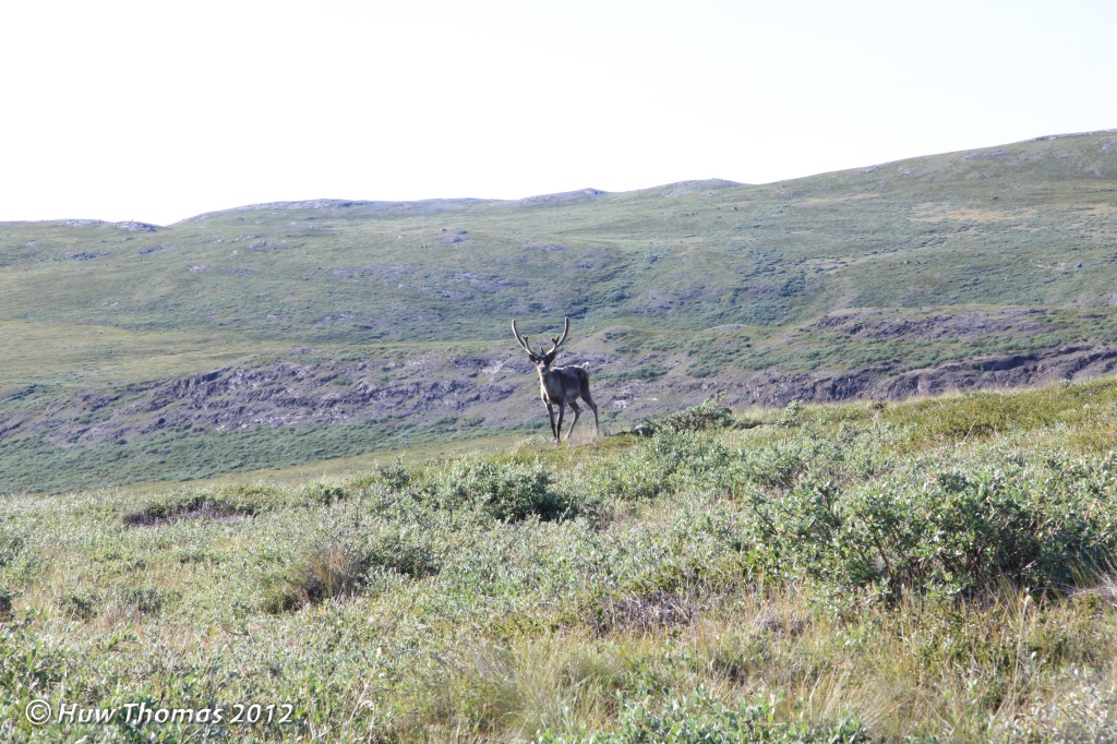
I climbed onto the mound to the east to look for a flattish stone where the vegetation was scarcer and found one, but then I spotted an even better one, about an even inch thick. This would make a nice stable base for my stove in the soft grass. Wildcampers will know that we all for some reason find a strange comfort in photographing pans on our stoves, maybe it’s something about how it signifies the comforts at the end of a day’s walking. However, I think it’s silly, so I don’t do that…!

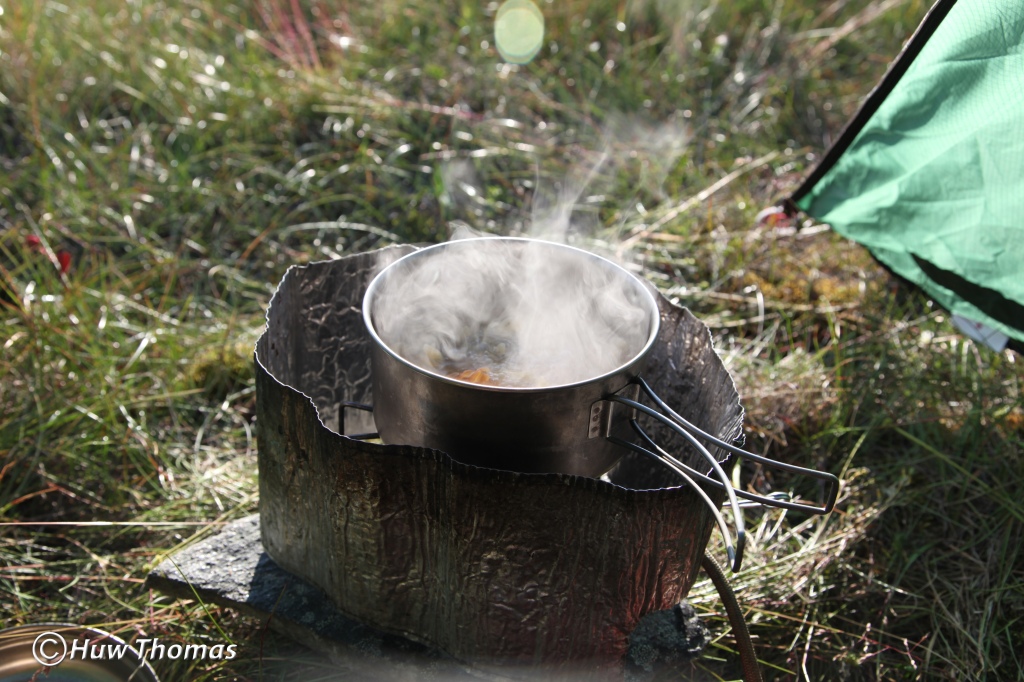
At 20:27 the sun was shining into my tent entrance pouring its warmth in. The mozzie-mesh was zipped up but it was so serenely peaceful out here alone in the wilderness and the silence. There’s something hard to describe about lying in your relatively flimsy portable home from home and the feeling of freedom to be in such a place that comes with it.

I was now 150km (93.3 miles) from my start point and although there would be some climbing to do, I expected to find my colleagues tomorrow. I had been given a location, by a small lake in the study area was where I should expect their static camp to be. So this would be my last night alone for this year. I was feeling pretty satisfied with having plotted my own route on the maps, found it in the real world and thoroughly enjoyed every moment of solitude and peace while making my way through such remote terrain. It had been challenging with a heavy pack, even by my own standards, but I feel a greater personal reward when I’ve had to work at it! If it was easy to do with a light pack of a few kilos, I would not feel much of a sense of personal endurance and achievement.
When with colleagues out here, they normally work in pairs but predictably, it is my preference to wander off and work alone during the days unless a goose-catch is the work of the day. On this hike, I had also found that deeper, more intense sense of isolation I had set out to find and it was pure pleasure to me. (So much so that at the time of writing I have repeated this trek twice more in subsequent years and with less to do by way of finding my way on those subsequent occasions, I documented so much more of the route photographically. I may write them up separately or look to combine each year’s experience into one narrative at some later point as each year had its differences). Moreover, I had also immersed myself more deeply into complete solitude, and far from unwelcoming, I found it to be a strangely tranquil and comforting place…on this occasion it was only the best part of 7 days…in 2018 I extended that to 17 days out here completely alone, seeing no other human person in all that time.
Wednesday the 18th of July (day 10): Last night’s camp was broken and I set off at 08:46 on another fine day of weather. Mosquito numbers were low and it was so good again to be able to leave the mozzie-net in the pack. It wasn’t far until I came to the outflow from this lake which proved to be a little tricky. The river ran in a deep large-bouldered gully heavily obscured by dwarf willow so I had to pick my way carefully to avoid dropping a foot into some unseen dark hole. (I have done that in the east! I was walking up a narrow pass beside a river when suddenly my foot found nothingness and instantly I dropped to the ground into a sitting position with one leg bent at the knee under my chin and the other dangling loosely in a hole with nothing solid beneath it. Fortunately, I was carrying only a day pack so nothing was injured and I managed to extricate myself relatively easily…).
I made my way through an unfamiliar long marshy area in gently sloping terrain, then walked up a long dry valley in which there was more of that spongy grassy terrain into which your boots sink deeply. This is very dry stuff in this weather, it kicks up a lot of dust and saps your strength…a bit like walking in sand. It feels so delicate and untouched that you feel a little guilty at crushing small areas of it under your boot!
After a few hours of walking up through this dry, silent countryside, passing some small lakes where I found a pair of Canada geese with 4 young and 15 Mallards and then a stiff climb, I topped out over a larger lake at which I found thirteen adult Canada geese with 17 juveniles. I was back in goose country! I made my way around the lake and up onto higher ground beyond. Then, with a warm feeling of familiarity, I found myself looking east over a lake I know well and could just make out the ice sheet in the distance. Strangely…considering that I was in the wilds of West Greenland… I felt as though I was ‘home’! I had now reached a very large area with which I am very familiar and while I knew exactly what my route ahead looked like, I also knew that I still had quite a bit of walking to do to reach my colleagues today.
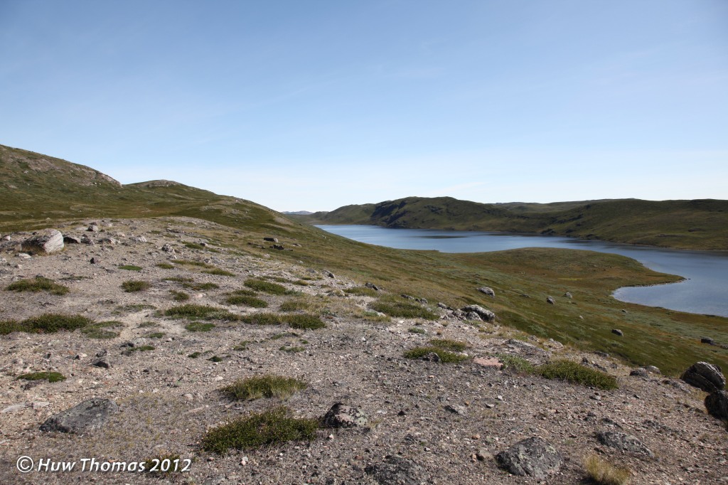
At the end of a very long familiar lake I found twenty six adult Canada geese all out on the water…that was probably because they had seen me coming for some distance, long before I saw them! I was positive some were marked but on such a large lake, at distance and with the shimmering surface reflecting sunlight, it would be too hard to try to read them. It was quite possible I would be back in this area over the next two weeks or so anyway to survey for geese so I let them be and continued on my way east. After reaching the next familiar lake I found it had thirty two Mallards on it and stopped to sit on a large rock for a bite of lunch. When I set off again, I switched my Garmin GPS unit on and happened to notice that it was displaying my distance from the start as exactly on 100 miles (161km)…amusing!
This lake sits in a long wide valley which at the eastern end has a long stretch of marsh and a few pools. I have walked its shoreline many times and after the marshy bit, I made a short but steep climb past an abandoned fox den to some more lakes that are much favoured by the geese. The fox den was occupied when I was here some years earlier but has always been abandoned since. From these lakes there was a larger climb and I finally turned towards the appointed location which I approached from higher ground.
This year’s small team consisted of my long-time friend who leads the goose work out there (as a professional ornithologist), his daughter who had been out there with us before and two of her student friends. It was an odd feeling to suddenly see tents and other humans though probably even stranger to the two new girls to suddenly see a stranger appear without warning, standing high above their camp!
At about 17:00 I entered their camp and with greetings, I was handed a cup of hot soup followed shortly after by a bowl of pasta and a tin of mackerel in tomato sauce which went very well with it. It was a very nice welcome and my first conversation in over 6 days, the first time I’d had to speak out loud since I had bidden goodbye to the Greenlandic women at the Innajuattoq II hut and watched them disappear over the ridge on the ACT. A strange sensation at first…after so much time alone with my thoughts and nothing but my inner monologue!
My GPS recorded 102 miles…but in later years I found it’s actually 105 miles. So I had lost 3 miles during those periods when the GPS had been turning off. So having done 105 miles, most of it through rough terrain with a heavy pack, it was extremely pleasing to know that as I dropped it to the ground, I would now be in static camp for the rest of the month and wandering these familiar hills and valleys with just a day pack. I felt very satisfied with myself, and the knowledge that I could carry a pack weighing around 40Kg at the start over such a distance in wild terrain was some kind of measure of myself, for myself, and it was pleasing. My colleagues had walked 9 miles to this location, I had walked 105 miles to it but felt most richly rewarded for all that.
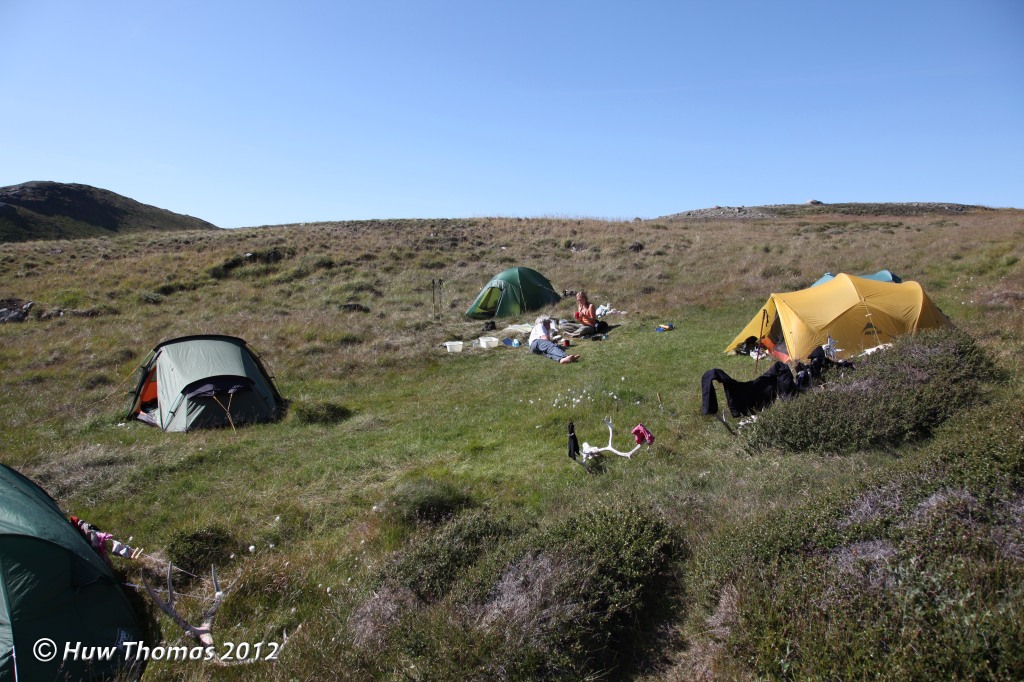
For the rest of the month, weather permitting, I would wake up to enjoy a view of the ice sheet in the east from this beautiful and remote place and spend my days in familiar lands, with a light pack, looking for the wildlife. This spot has become a favourite location for future years and each time I walk from Sisimiut to this place, I feel that I have quite earned the privilege. In 2017 and 2018 I was out here alone for the whole period, with no goose team, but those visits are for another time…


Okay got it 😜
Thanks Huw for your beautiful post hiking in the wild of West Greenland. I love it. Being out in this incredible infinity landscape in humble solitude. 🙂
LikeLiked by 1 person
Thanks Iris. We are alike in what we love about being out there. 🙂
LikeLike